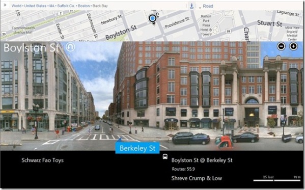
 Microsoft has tweaked Bing map in Streetside view. Streetside view which is available in US and Canada enables map users to experience Bing Maps from street level. The new changes represent a significant enhancement for desktop browsers, enabling you to quickly pan up and down the street to see the neighborhood and find businesses. Microsoft is doing this by providing street level panoramas so you can take a virtual walk through the streets with a view of locations and landmarks. As you slide the street level imagery sideways, the view of the sidewalk is seamlessly constructed including an overlay of business listings, street names and store fronts.
Streetside will supplement maps, directions and local search. Imagery is collected using a 360 degree camera mounted on an automobile. We drive public roads and other areas open to the public (e.g., parking lots), with our main focus on streets with businesses and points of public interest.
In the past you explored Streetside imagery by navigating between “bubbles,” or discrete 360 degree views, and moving down the street was accomplished by jumping from bubble to bubble. This works, but makes it difficult for you to get a sense for a larger area like a city block. Moreover, it’s hard to pick out storefronts farther away since you really only see the ones directly perpendicular to your viewpoint with great clarity.
This new style keeps the immersive experience but adds smooth left/right panning navigation that makes it easy to find what’s nearby more quickly. The street flows by as a series of smooth ground-level photographs so now you simply pan up and down the street to see the neighborhood and find what you are looking for.

[advt]While you are moving around in this new view you can keep track of where you are by looking at the street map above the imagery. Right below the images you will see an overlay of the names of businesses and bus stops, reducing clutter and providing location context.
Want to see what’s across the street? Click the “u-turn” icon next to the street name in the upper left of the image. Want to see what’s down a cross street? Just click on the street name, if there is Streetside imagery available for that area you will rotate onto it.
This feature is the product of a technology transfer from the Microsoft Research Interactive Visual Media group’s Street Slide project, which demonstrated how street-level visualization and navigation could be dramatically improved.


Be the first to comment