Google recently released Google Earth streaming technology to deliver 3D satellite images of the earth right on to your desktop. See my previous post on Google Earth. I have been playing with it for some time now. It is really helpful to find places in the US. For US cities, I always look at Google Earth image and will have a better understand of the place before driving into there, you will not miss any roads or exits.
Another advantage is that, you can easily find out latitude and longitude of any place in the world, which is displayed in the dashboard of the application. if you know the latitude and longitude of two places, you can find the surface distance between these points, This webpage calculates the direct surface distance between Technopark and my home as 21 kilometers!
Recently Google Earth made available high resolution graphics for Indian metros like Bangalore, Hyderabad and Delhi. Try it out in Google Earth.
Google Earth allows to share data and place marks with other users in KML/KMZ file format. I have recently created a Google Earth file with placemarks for places in and around Thiruvananthapuram city. Download the place marks file and open it in Google Earth. If you do not have Google Earth, download Google Earth software and install in your computer, you will never regret. After opening the KMZ file in Google Earth, click on a place name to fly to there! You can zoon in/out to get clearer picture. See the screen shot below.
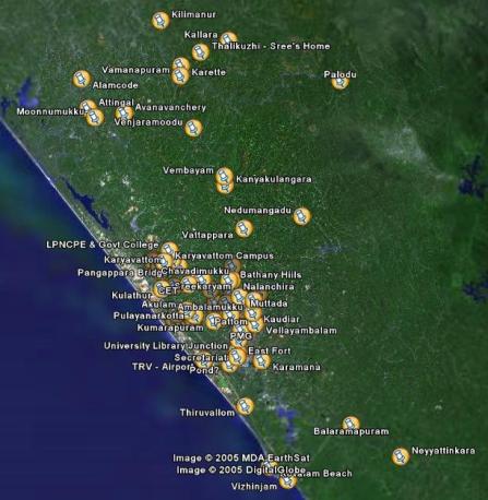
I have marked places like East Fort, Secretariat, Airport, PMG, Pattom, Ullur, Medical College, Kesavadasapuram, Paruthippara, Nalanchira, Mannanthala, Vattappara, Muttada, Ambalamukku, Peroorkada, Kaudiar, Kuravankonam, Vellayambalam, Karamana, Thiruvallom, Kovalam, Vizhinam, Balaramapuram, Neyyattinkara, Pongumoodu, Sreekaryam, Chavadimukku, College of Engineering, Monvila, Kulathur, Karyavattom, Technopark, Kazhakuttom, Cosmo, KIMS, Medical College, Kumarapuram, Akkulam, Pulayanarkottah, Veli, Attingal, Avanavanchery, Alamcode, Nilamel, Palodu, Nedumangadu, Vattapara, Vembayam, Venjaramoodu, vamanapuram, Karette, Kilimanur, Kallara, and my village Thalikuzhi too!
Hope my guess work is correct, and hope to add more places soon. Let me know if there is any error in my placemarks.

Be the first to comment