Google has provided the latest available high-resolution imagery of areas affected the most by the devastating earthquake and subsequent tsunami that struck Japan. Google has worked with their satellite imagery partners GeoEye to make this possible.
You can download the KML file and explore the imagery in Google Earth. You can also explore the imagery with Google Maps. Google has also provided the satellite imagery in Picasa web album, taken before and after the earthquake and tsunami.
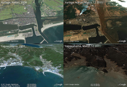
Above is Yuriage in Natori, below is Yagawahama; both are in Miyagi prefecture.
Google provides this valuable data directly to response organizations on the ground to aid their efforts, which will help illustrate the extent of the damage. [source]
Watch the Earthquake Videos
httpvp://www.youtube.com/view_play_list?p=0870831CE43351E1

Be the first to comment