There would have been many cases when you wanted to find out the latitude and longitude of places. For example, to add Geotagging for your blog or to find Rahukalam or for astrology services, you would like to know the exact latitude and longitude of the location. Thanks to technology, you can use Google Maps to find this information. Even though Google Maps do not display latitude and longitude of places on the screen, it uses the lat – long internally. Given below are a few easy methods for finding the exact lat lng of any location on the Earth.
1: “What’s Here” Feature of Google Maps
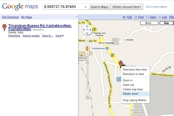
If you’re browsing Google Maps and want to know the coordinates of a location, just right-click on the map and select “What’s here?”. The coordinates will automatically be filled up in the search box.
2. LatLng Tooltip
The LatLng tool displays a tooltip next to the mouse cursor showing the latlng directly underneath it. This tool is currently part of the Google Maps Labs, so you will have to enable it manually.
How to enable it?
- Goto http://maps.google.com/maps?showlabs=1
- Enable LatLng Tooltip
- Save Changes made
On mouse over, you will get the latitude and longitude of each spot.
[advt]
3. LatLng Marker
The LatLng Marker adds an option to the context menu that lets you drop a mini marker showing the latlng of the position that the cursor was pointing at when the context menu was evoked. You can drop as many markers you need. LatLng Marker tool is also in the the Google Maps Labs, so you will have to enable it manually.
How to enable it?
- Goto http://maps.google.com/maps?showlabs=1
- Enable LatLng Marker
- Save changes made
Right click on the place, select drop LatLng Marker, now you will get the latitude and longitude of that place in a pop up window.


Be the first to comment